Great Mississippi Flood of 1927: Causes, Destruction and Federal Response
Why the Mississippi River’s levees failed in 1927, how communities were displaced and what the disaster revealed about flood control and racial inequality.
Quick answer
The Great Mississippi Flood of 1927 was one of the most destructive river floods in U.S. history. Record rains and high river levels overwhelmed levees across the lower Mississippi Valley, inundating approximately 27,000 square miles across several states according to the National Weather Service. The agency cites 246 flood-related deaths and massive displacement. Relief work was coordinated through federal agencies and the American Red Cross, with Commerce Secretary Herbert Hoover taking a prominent role. The disaster accelerated debate over federal flood-control policy.
Key facts
On this page
- What made the 1927 flood so destructive?
- The conditions before the spring crest
- The Mounds Landing levee break
- What happened to towns and farms?
- Displacement and the refugee camps
- Herbert Hoover’s role in relief
- Race, labor and the Mississippi Delta
- How many people died?
- Why the Flood Control Act of 1928 followed
- Legacy of the 1927 Mississippi disaster
- Timeline
- FAQs
- Sources
What made the 1927 flood so destructive?
The Mississippi River and its tributaries drain a vast part of North America, gathering water from rainfall and snowmelt over many regions. During 1926 and early 1927, persistent heavy rains raised levels across the river system. By spring, the lower Mississippi carried enormous flows that threatened communities, farmland and the levees built to protect them. The disaster was not simply a local thunderstorm or one dam breaking. It developed through prolonged pressure on a complicated network of rivers and human-built defenses.
As water continued rising, levees failed or were deliberately opened in some locations, sending floodwaters across extensive low-lying areas. The National Weather Service estimates that around 27,000 square miles were inundated. The figure is an approximate multi-state total, not the size of a single lake or one county. Houses, transportation routes, farmland and businesses were affected, and relief systems struggled to keep pace with the scale of human displacement.
The conditions before the spring crest
Months of unusually wet weather saturated the watershed and contributed to high flows well before the most dramatic breaks. Tributaries added water to the main river, and the sheer volume moving south exceeded what some protective structures could contain. Hydrologists emphasize that a major river flood may reflect weather across distant regions rather than conditions immediately above one town. Residents near the lower river could face dangerous levels even when the heaviest rain had fallen hundreds of miles away.
Early warning and flood forecasting were far less sophisticated than today’s satellite-based systems. Officials monitored gauges and communicated by available transport and telegraph networks, but precise flood mapping and coordinated evacuation were difficult. Community members had to decide whether to move belongings, livestock or families as the danger increased. Some delayed because leaving could mean abandoning a home, crop or wage-earning opportunity. Such decisions involved risk and uncertainty, not simply a refusal to heed clear modern warnings.
The Mounds Landing levee break
On April 21, 1927, a major levee failure at Mounds Landing near Greenville, Mississippi, released enormous volumes of water into the Yazoo-Mississippi Delta. The breach became one of the best-known events of the flood because of its consequences for farms, towns and rural communities. Water spread across large tracts of the Delta, making roads and rail lines unusable and forcing people to seek higher ground or evacuation.
The breach was a watershed moment within a disaster that already spanned multiple states. It should not be mistaken for the sole cause of the flood. Other levees failed, and different communities experienced the rising river at different times. The Mounds Landing story nevertheless shows how a levee system can create a dangerous dependence on a protective structure: when a high barrier fails, the resulting rush of water can be far more sudden than slow natural overbank flooding.
What happened to towns and farms?
Large stretches of agricultural land remained under water for weeks or months. Homes were submerged or moved from their foundations; livestock died, tools and stored goods were lost, and planting schedules were disrupted. Some residents could not return quickly even after the river began falling because roads, wells and buildings needed repair. The physical damage was joined by losses of income and debts that continued beyond the visible floodwaters.
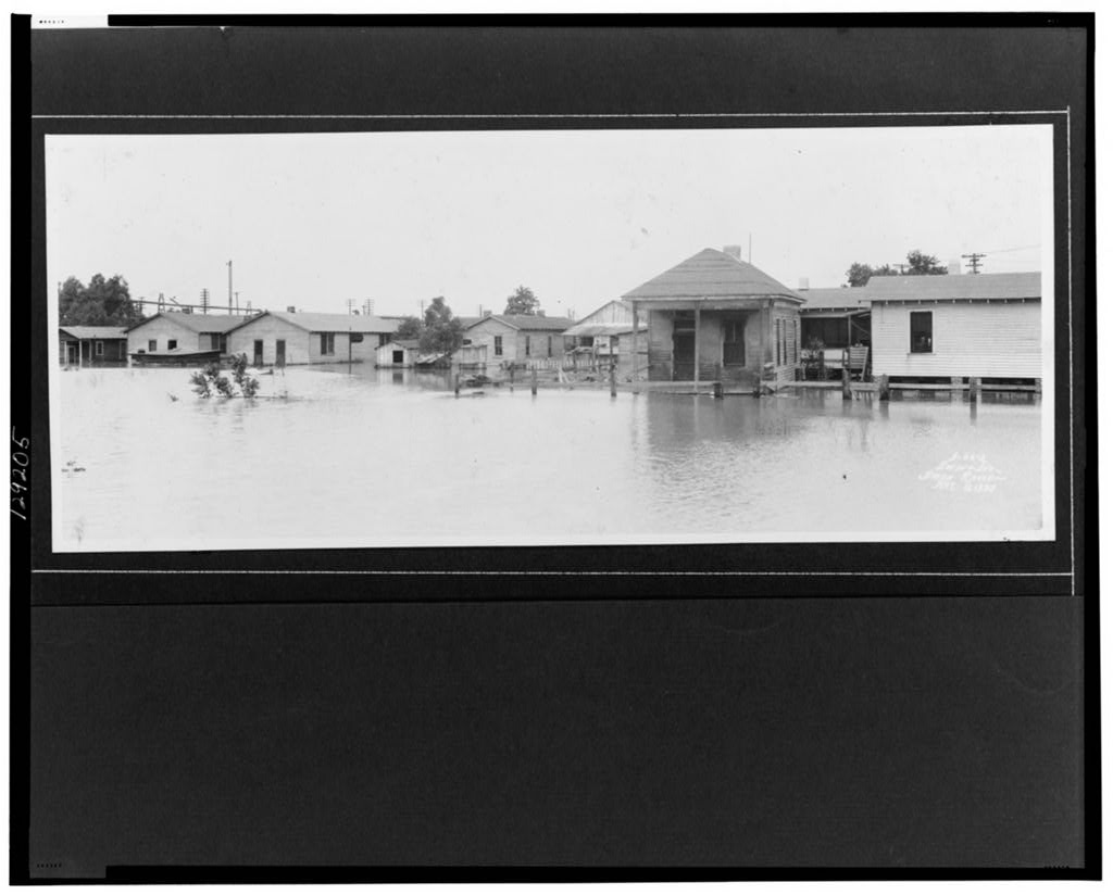
The 1927 photograph accompanying this article records houses surrounded by water in Louisiana on May 11. Its date and location are established in the Library of Congress catalog. It shows the destructive reach of flooding, but it cannot represent every community in the lower valley. Local conditions differed, and the disaster covered several states. A dated archival image is more useful than a generic modern flood picture labeled as though it were taken in 1927.
Displacement and the refugee camps
Hundreds of thousands of people were forced from homes or sought temporary shelter. The American Red Cross and local agencies established camps, distributed supplies and coordinated rescues. Boats, trains and improvised shelters were essential where roads were flooded. The scale of the emergency placed enormous demands on volunteers, officials, transport systems and public donations. Relief work was both a humanitarian effort and a major administrative undertaking.
Camp conditions varied, and not all residents received equal treatment. In parts of the Delta, Black sharecroppers were subject to coercive restrictions and unequal distribution of relief. Some were pressured to remain on plantations or in local camps because landowners feared losing their workforce. Historians use Red Cross records and testimony to assess these abuses. The disaster therefore reveals not just the force of the river but how existing economic and racial power shaped survival and recovery.
Herbert Hoover’s role in relief
President Calvin Coolidge assigned Commerce Secretary Herbert Hoover a prominent coordinating role in flood relief. Hoover worked with the Red Cross, officials and local organizations to organize aid, raise funds and publicize the emergency. His visibility in the response became part of his national political reputation before the 1928 presidential election. It would be misleading to say Hoover personally rescued every flood victim or that the federal government alone provided all assistance.
Private charities, state governments, local communities and ordinary residents played major roles. The national coordination nonetheless demonstrated growing expectations that federal leaders would help manage catastrophes beyond one state’s capacity. Hoover’s actions were praised by many contemporaries, while the treatment of Black refugees attracted criticism. Assessing his role requires holding those aspects together rather than using the disaster only as a prelude to his later presidency.
Race, labor and the Mississippi Delta
The lower Mississippi Valley had an agricultural economy shaped by segregation, sharecropping and unequal land ownership. Many African American families worked land they did not own and depended on local employers or landowners for access to credit and supplies. These relationships affected choices during an emergency. Moving away from a flooded area could mean losing work or housing, while staying might expose people to dangerous conditions and coercion.
Relief arrangements reflected that hierarchy. The historical record documents discrimination in refugee camps and efforts to retain Black farm laborers. Such actions were not a natural consequence of water levels; they were human decisions embedded in social power. The history of sharecropping and the Great Migration help explain why some Black families considered leaving the Delta after the disaster, although migration was already under way before 1927.
How many people died?
The National Weather Service’s Mississippi flood history lists 246 flood-related deaths across several states. Other popular accounts cite different totals because the definition of a flood death, geographical scope and completeness of historical records can vary. A responsible article should state its source rather than combine numbers from different methods and present the result as an exact count. The 246 figure is an official historical estimate and does not mean all losses were documented perfectly.
The human consequences extended far beyond fatalities. Displacement, disease risks, destroyed livelihoods and long-term debt affected families who survived. Some communities lost access to schools or doctors for extended periods. Numbers describing flooded acreage or people in camps can convey scale, but they cannot capture every individual experience. Historical research needs personal accounts, local records and photographs alongside aggregate figures.
Why the Flood Control Act of 1928 followed
The catastrophe intensified pressure for a stronger federal role in managing Mississippi River flooding. Congress passed the Flood Control Act of 1928, which supported major flood-control projects and the development of a more comprehensive approach to the lower Mississippi Valley. Engineers planned levees, spillways, floodways and other works rather than relying on a single protective method. The law reflected a new willingness to invest federal resources in a problem that affected several states at once.
The later system did not eliminate flooding or remove every risk associated with levees. Engineering works can reduce hazards while shifting water and risks to other locations. Changes in land use, settlement and river dynamics also complicate planning. The 1927 event was a turning point in policy, not a promise that the river could be made perfectly controllable. The National Archives documents the growth of federal river engineering and the persistence of difficult decisions about floodplain development.
Legacy of the 1927 Mississippi disaster
The flood is remembered for its geographic extent, failure of river defenses and the enormous scale of relief work. It changed public expectations about government action and contributed to Hoover’s national prominence. At the same time, it exposed serious discrimination in emergency assistance and economic vulnerability among sharecropping communities. Those intertwined histories are essential to understanding the disaster’s lasting effects.
The best historical explanation begins with the hydrology of the Mississippi system but does not end there. Weather and water explain why a flood occurred; levee design, settlement, labor relationships and political decisions explain much of the damage and differential treatment. The 1928 election article provides the subsequent political context, while archival photographs from May 1927 preserve evidence of what the inundation looked like on the ground.
Timeline
- Late 1926–early 1927: Heavy rains saturate Mississippi River watershed
- April 21, 1927: Mounds Landing levee breaks
- April–May 1927: Widespread inundation and emergency relief
- May 11, 1927: Library of Congress flood photograph taken in Louisiana
- 1927–28: Recovery and policy debates
- 1928: Flood Control Act enacted
Frequently asked questions
When was the Great Mississippi Flood?
Its most destructive period was spring 1927, especially April and May, with some areas affected longer.
How large was the flooded area?
The National Weather Service estimates about 27,000 square miles across several states.
How many people died?
The National Weather Service lists 246 flood-related deaths; other historical counts vary by method.
What happened at Mounds Landing?
A major levee broke on April 21, 1927, spreading water across the Mississippi Delta.
What was Herbert Hoover’s role?
As commerce secretary, he coordinated prominent relief efforts with the Red Cross and other organizations.
Did the flood affect Black communities unequally?
Yes. Segregation, sharecropping and discriminatory camp practices shaped the experience of many Black refugees.
What federal law followed?
The Flood Control Act of 1928 supported major federal flood-control work.